The analytical basis of the Development Plan will include analyses of the existing situation and data collected from the following fields: Society (demography, social infrastructure and education, health, social welfare and social inclusion), Economy (general economic trends, labour market, business environment, tourism and culture), Urban environment (quality of urban environment, exposure to environmental risks and climate hazards, primary infrastructure, infrastructure for mobility and internet connection, framework for managing development) and SWOT analysis.
Basic information about Rijeka form an integral part of the Analytical Basis.
CITY OF RIJEKA – BASIC DATA:
- County: Primorje – Gorski Kotar
- Geographic location 45.3271 ° N, 14.4422 ° E
- Land surface: 43.6 sq. km
- Total area (with sea part): 136 sq. km.
- ZIP: 51,000
- License plate: RI
- Number of local boards: 34
- Population: 2011 = 128,624; 2018 = 117,415
- Population density: 2,923 s / km2
- Dialect: Kvarner Chakavian
- Climate: Moderately warm rainy climate
- City’s patron saint : St. Vitus
- City Day: June 15
- NUTS2 region: Adriatic Croatia
- Development index: 108,308
- JLS Development Group: VII
- Predominant, the most important activities: Manufacturing; Construction; Wholesale and retail trade and repair of motor vehicles and motorcycles; Transportation and storage; Professional, scientific and technical activities
- Other special features: European Capital of Culture
The city of Rijeka is located in the Primorje-Gorski Kotar County (NUTS II region – Adriatic Croatia) and, as the county capital, it represents its centre. It is one of the four basic development centres of single territorial units of the Republic of Croatia together with Zagreb, Split and Osijek. Throughout history, Rijeka, with numerous factories in various industries and a developed port, was known as an industrial and port centre, and today, although it is still recognised for the mentioned factors, Rijeka is recognised for new industries, education, culture and tourism. Administratively, the city is divided into 34 local boards: Banderovo, Belveder, Brajda-Dolac, Brašćine-Pulac, Bulevard, Centar-Sušak, Draga, Drenova, Gornja Vežica, Gornji Zamet, City of Trsat, Grbci, Kantrida, Kozala, Krimeja, Luka , Mlaka, Orehovica, Pašac, Pećine, Pehlin, Podmurvice, Podvežica, Potok, Srdoči, Sveti Kuzam, Sveti Nikola, Svilno, Školjić – Stari grad, Škurinje, Škurinjska Draga, Turnić, Vojak and Zamet
Spatially, it is located on the northern edge of the well-protected Bay of Rijeka, and the coastline, which stretches from Preluk Bay on the west side to Martinšćica Bay on the eastern edge of the city, in regard to the city’s triangular shape, it represents its hypotenuse 19 km long. On the land side, Rijeka borders the towns of Bakar, Kastav and Opatija and the municipalities of Čavle, Jelenje, Kostrena, Matulji and Viškovo, and on the sea side the towns of Kraljevica and Cres and the municipality of Omišalj. The Rijeka seawater makes part to the Bay of Rijeka, the northernmost part of Kvarner located between the western coast of Krk, the Istrian peninsula and the northern part of the Croatian coast, where the largest Croatian port and numerous tourist centres have developed. The Bay of Rijeka is a closed system connected to the Kvarner Bay by Tihi Kanal to the east, Srednja vrata to the south and Vela vrata to the southwest.
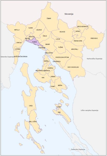
THE POSITION OF THE CITY OF RIJEKA IN THE PRIMORJE-GORSKI KOTAR COUNTY SOURCE: PUBLIC INSTITUTION FOR SPATIAL PLANNING OF THE PRIMORJE-GORSKI KOTAR COUNTY
Position of the City of Rijeka in the Primorje-Gorski Kotar County
The geological location of Rijeka makes it very sensitive to rainfall, on average, one third of all days are rainy days. The prevailing climate is a moderately warm rainy climate, with no dry period, with a minimum of precipitation in the warm part of the year and with hot summers. The mean annual air temperature is about 13.8 ºC, and the absolute maximum and minimum temperature were respectively 38.1 ºC and –11.4 ºC. This temperature ratio throughout the year in the territory of Rijeka opens up numerous possibilities. The highest surface temperature of the sea in the Bay of Rijeka is in August (22.4 ºC), which is (in the summer months) extremely suitable for bathing tourism. In contrast to bathing tourism, and related to lower temperatures during winter, in the territory of the City of Rijeka, more precisely in the Platak ski resort, winter tourism is promoted. It is a rarity in the world to have swimming in summer and skiing in winter with a sea view.
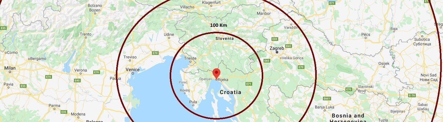
The city is located near most centres of the neighbouring counties. Distance to Pazin (Istria County) is 60 km, Karlovac (Karlovac County) 140 km, Gospić (Lika-Senj County) 155 km and Zadar (Zadar County) 225 km. Distance to the capital of the Republic of Croatia, Zagreb, is 175 km. In addition to these cities, within a radius of about 100 km there are major cities in the region, Pula, Trieste and Ljubljana, and at a distance of about 500 km are most of the capitals and centres of Central Europe, Budapest, Bratislava, Vienna, Milan, Munich, Salzburg and others.
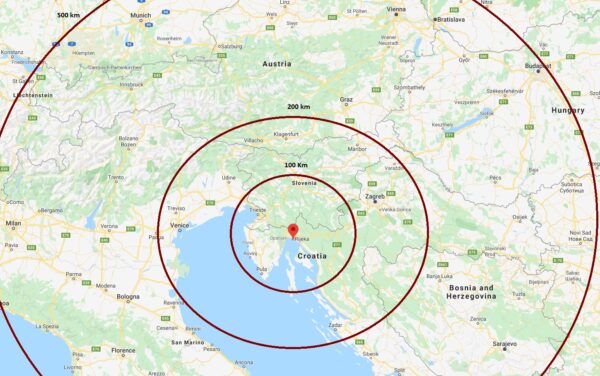
DISTANCE OF THE CITY OF RIJEKA FROM DOMESTIC AND FOREIGN CENTRES; PREPARATION: AUTHORS OF THE PLAN ACCORDING TO GOOGLE MAPS
Distance of the City of Rijeka from domestic and foreign centres
Further chapters of the Analytical basis are being prepared. They relate to the following chapters
- Society (demography, social infrastructure and education, health, social welfare and social inclusion),
- Economy (general economic trends, labour market, business environment, tourism and culture),
- Urban environment (quality of urban environment, exposure to environmental risks and climate hazards, primary infrastructure, infrastructure for mobility and internet connection, development management framework)
- SWOT analysis.